
User Tag List
Results 165,376 to 165,390 of 176708
 1334446Likes
-
Sat, Apr 14th, 2018, 07:02 AM #165376
Happy Caturday Q sters,
A wet start so far, but not icy yet.
Take care & be safe.
NASCAR SEASON is complete for 2021.
Kyle Larson wins his 1st Nascar Championship.

nascar:a way of life
everything else is just a game
-
-
Sat, Apr 14th, 2018, 07:03 AM #165377
7am bullseye guess - 99
Sent from my SM-A520W using TapatalkNASCAR SEASON is complete for 2021.
Kyle Larson wins his 1st Nascar Championship.
nascar:a way of life
everything else is just a game
-
Sat, Apr 14th, 2018, 08:35 AM #165378
 Presale ZZ Top
Q107 WELCOMES: ZZ TOP Saturday, August 18th at Casino Rama Resort! Q107 is hooking you up with the chance to buy tickets to ZZ Top on Saturday, August 18th at Casino Rama Resort! Tickets for this show go on sale on Saturday, April 14th at 12:00pm! But since youre a member of Club Q, [ ]
Full Details
-
Sat, Apr 14th, 2018, 08:37 AM #165379
next guess at 11:00 for
$6700
Previous guesses:
https://docs.google.com/spreadsheets...it?usp=sharing
-
Sat, Apr 14th, 2018, 08:45 AM #165380
Good morning qts.
Just as some predicted. The heat was getting too much for the orange one so he's created a diversion.
-
Sat, Apr 14th, 2018, 09:11 AM #165381
The freezing rain started about 15 min ago and already everything is nicely glazed.
Be careful out there.
-
Sat, Apr 14th, 2018, 09:38 AM #165382Been pouring rain down this way, with the odd ice pellets every once & a while. Hoping it holds off on the ice till after I finish work & get home. Yeah right.
 Originally Posted by heartgirl99
 NASCAR SEASON is complete for 2021.
Kyle Larson wins his 1st Nascar Championship.
nascar:a way of life
everything else is just a game
-
Sat, Apr 14th, 2018, 09:41 AM #165383Newfiescreech


- Join Date
- Oct 2006
- Location
- Newfoundland , Canada
- Posts
- 7,708
- Likes Received
- 24313
- Trading Score
- 0 (0%)


-
Sat, Apr 14th, 2018, 09:50 AM #165384Newfiescreech
- Join Date
- Oct 2006
- Location
- Newfoundland , Canada
- Posts
- 7,708
- Likes Received
- 24313
- Trading Score
- 0 (0%)
So far its lovely morning here ..sun is shining now ..be careful HTeam going home today ..take care sweetie Originally Posted by the H team
-
Sat, Apr 14th, 2018, 09:51 AM #165385Canadian Guru


- Join Date
- Dec 2014
- Location
- Near Apsley On for the summer
- Posts
- 16,831
- Likes Received
- 78207
- Trading Score
- 0 (0%)
Happy Saturday everyone!
Just rain here so far but i'm sure we will get the freezing rain.


-
Sat, Apr 14th, 2018, 10:01 AM #165386Newfiescreech
- Join Date
- Oct 2006
- Location
- Newfoundland , Canada
- Posts
- 7,708
- Likes Received
- 24313
- Trading Score
- 0 (0%)
Sun ☀️ is out , it could be lovely day after all here ..stay safe EVERYONE and have wonderful weekend..take care
-
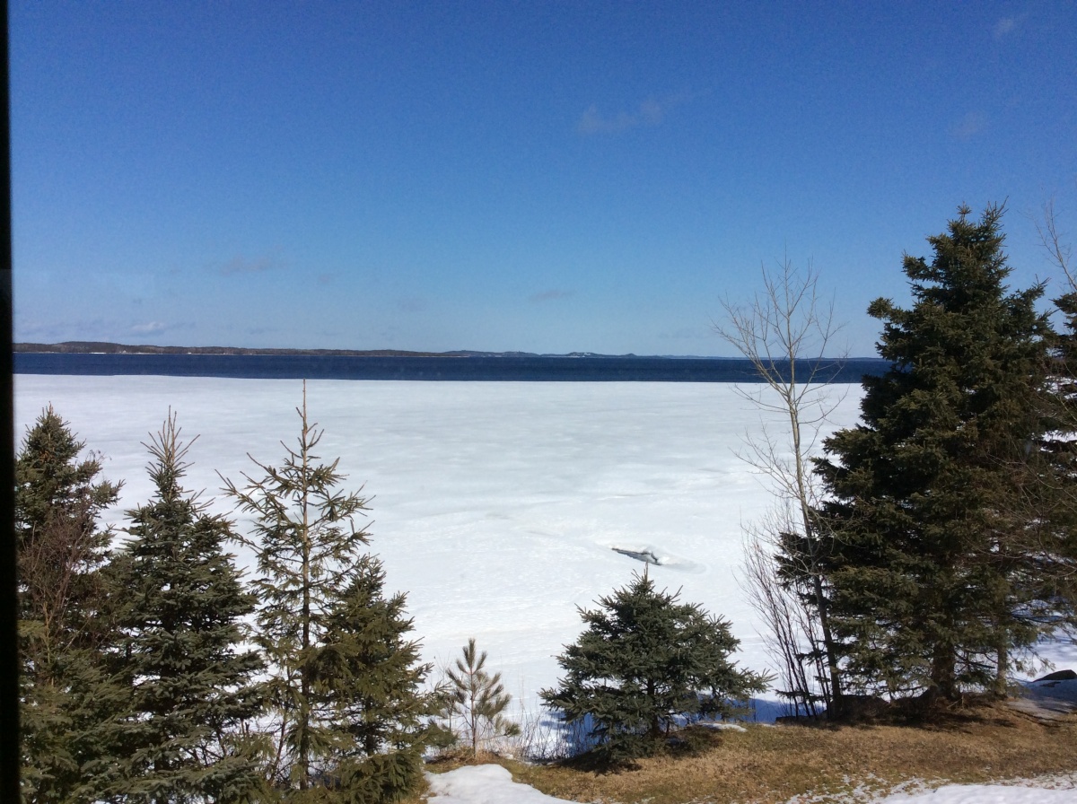
Sat, Apr 14th, 2018, 10:05 AM #165387Looks beautiful..................except what's that white stuff?????????????? Originally Posted by Newfiescreech
 NASCAR SEASON is complete for 2021.
Kyle Larson wins his 1st Nascar Championship.
nascar:a way of life
everything else is just a game
-
Sat, Apr 14th, 2018, 10:42 AM #165388

Dangerous Winter Storm to Impact Southern Ontario This Weekend With Significant Freezing Rain, Snow and Rain.NASCAR SEASON is complete for 2021.
Kyle Larson wins his 1st Nascar Championship.
nascar:a way of life
everything else is just a game
-
Sat, Apr 14th, 2018, 10:50 AM #165389
Unfortunately, it appears that colder air will end up further south than expected resulting in the risk of an ice storm stretching as far south as London and Niagara Falls. Further north into sections of Central Ontario they can expect to see very heavy snowfall during the weekend with some areas picking up as much as 20-40cm.
To help you better plan out your weekend weve broken down our forecasts into two timing maps for Saturday and Sunday. You can also find the total freezing rain and snow/sleet accumulation maps at the end of this forecast.
Saturday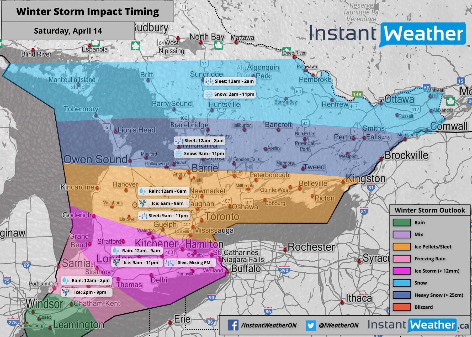 As this first wave of precipitation moves into our region, well see mostly rain to start off with. Throughout the morning on Saturday, the temperatures will slowly drop below the freezing mark beginning in the north and progressing south. During this time, there is the risk of brief freezing rain north of a line from Goderich to Mississauga.
East of Georgian Bay and into Eastern Ontario, the rain will turn to ice pellets/sleet for a few hours then over to heavy snow that will last for the rest of the day.
The area south of Lake Simcoe including the GTA will experience several hours of freezing rain in the morning, turning to ice pellets by late morning and those pellets will continue into the evening, mixing in with rain.
The Niagara region and regions north of Lake Erie including Hamilton, Kitchener/Waterloo and London can expect many hours of freezing rain beginning late morning. Later in the evening, there might be some ice pellets that mix in at times.
Further south into Extreme Southwestern Ontario including Sarnia and Windsor, this area will see mostly rain storms. Although, there is a short timeframe where a few hours of freezing rain might be possible within the Sarnia region. Flooding is definitely a concern with all the rain, especially in low lying areas that are prone to flooding.
The precipitation will begin to taper off late Saturday giving way to a short dry slot before a second wave moves in early Sunday morning.
Sunday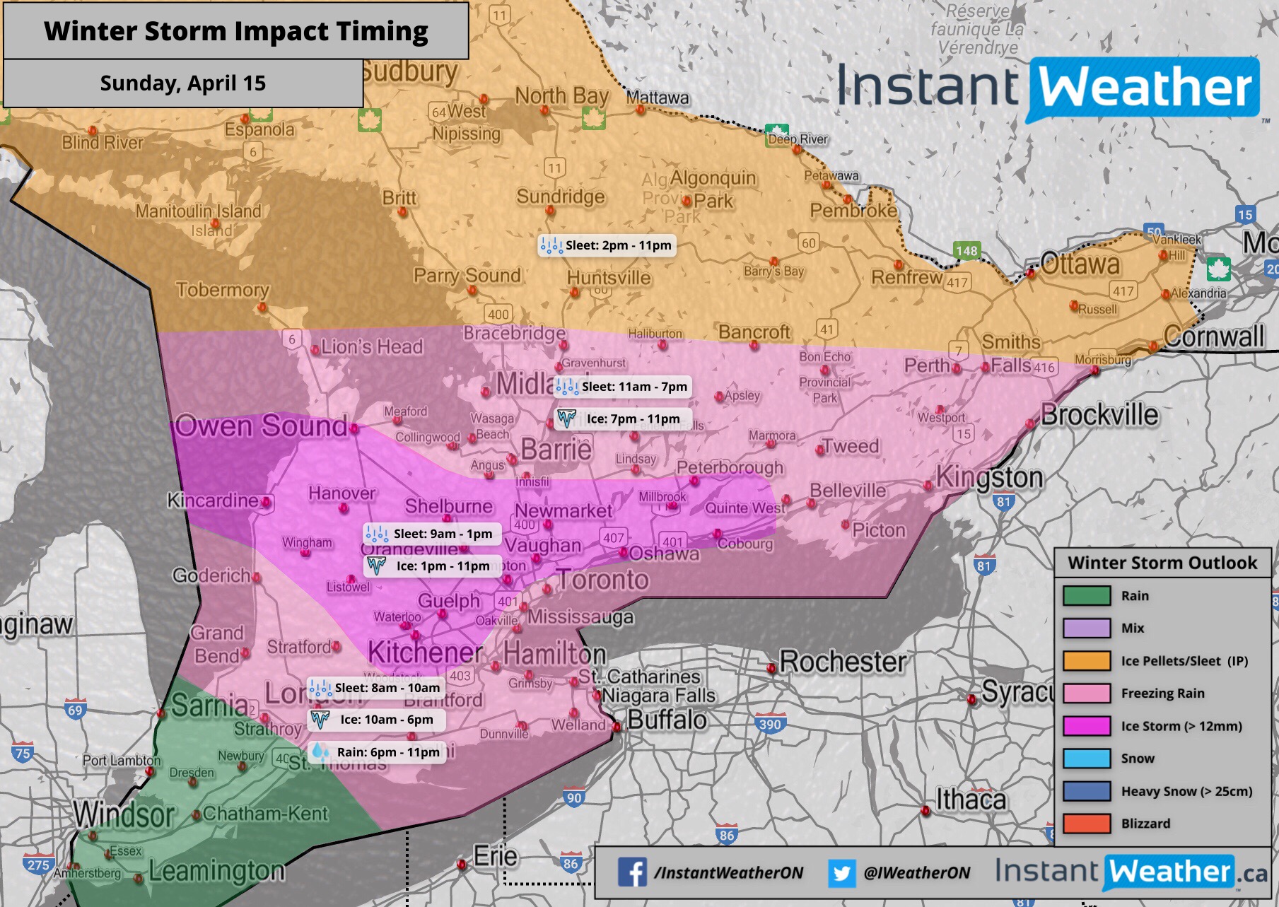 As mentioned above, another round of precipitation will move into our region from the south during the morning hours on Sunday. It will begin as ice pellets and slowly transition over to freezing rain. For some areas within Southwestern Ontario, the freezing rain is expected to be quite heavy and last for most of Sunday. Combined with wind gusts that could reach 50-100km/h, this will inevitably result in widespread power outages that could last for days.
Temperatures will start to slowly climb towards the freezing mark starting in the south during the afternoon on Sunday. Areas close to Lake Erie will begin to transition over to regular rain. The line of freezing rain will progressively move north as more areas warm up enough to get over the freezing mark. The City of Toronto will likely warm up quicker than surrounding regions within the GTA so it could limit ice accretion. Although, you dont have to go far from the lakeshore to get into substantial ice accretion.
By Sunday night, most areas with the exception of Central and Eastern Ontario will have transitioned to regular rain. The rain will be quite heavy throughout the night and could lead to flooding. Impacts of the storm will still be felt into Monday morning with icy road conditions and the potential for power outages throughout Central and Eastern Ontario. At this point, school bus cancellations look quite likely for Monday within those regions, but this depends on the timing and how this storm plays out over the weekend.
Accumulation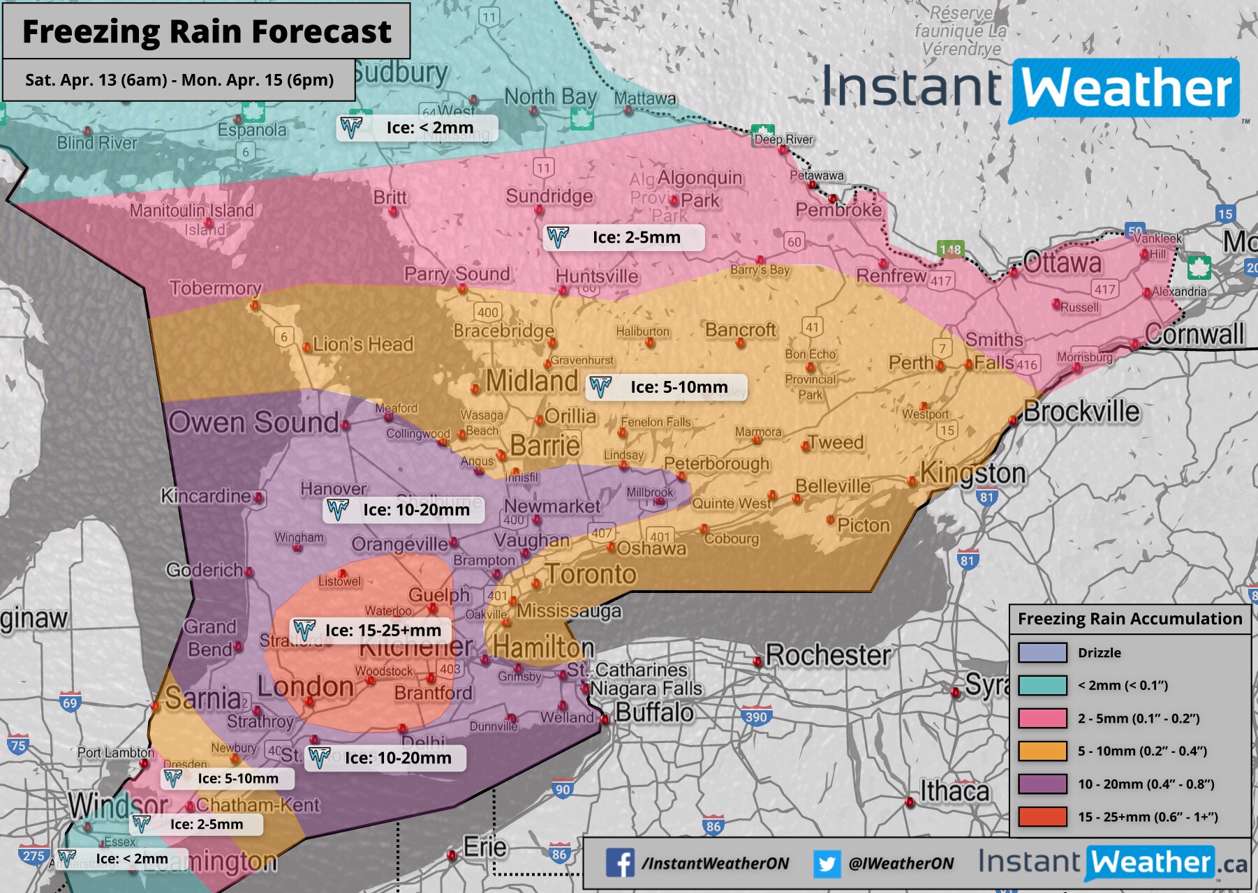
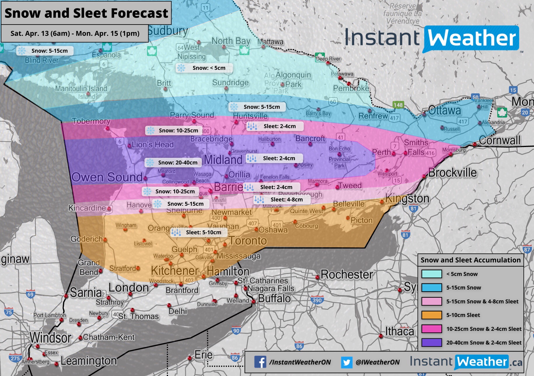 The heaviest freezing rain is expected throughout the Niagara Escarpment, into Kitchener/Waterloo and potentially into parts of the GTA. Some areas within this region could see anywhere from 15-25mm of ice accretion between the two waves. We cant rule out locally higher amounts around the London and KW regions.
Snow and ice pellets/sleet will be the predominant precipitation north of a line from Goderich to Mississauga. South of Lake Simcoe, heavy ice pellets throughout Saturday will result in accumulation of 5-10cm. While this may not seem like much its important to note that ice pellets have much more moisture content compared to snow. This means only a small amount can have a big impact on travel.
Snowfall
East of Georgian Bay including Simcoe County and Southern Muskoka, up into Sudbury and North Bay is where we expect the heaviest snowfall accumulation to occur. Theres some uncertainty in exact amounts so the range is quite large at this time from 20-40cm. Depending on the track, we may see the swath of the heaviest snow shift which could change this dramatically. Especially for Barrie and surrounding areas.NASCAR SEASON is complete for 2021.
Kyle Larson wins his 1st Nascar Championship.
nascar:a way of life
everything else is just a game
-
Sat, Apr 14th, 2018, 11:05 AM #165390
11am bullseye guess - 67
Sent from my SM-A520W using TapatalkNASCAR SEASON is complete for 2021.
Kyle Larson wins his 1st Nascar Championship.
nascar:a way of life
everything else is just a game

 Send PM

Thread Information
Users Browsing this Thread
There are currently 20 users browsing this thread. (0 members and 20 guests)
Tags for this Thread
again lobster tales?,
ah ha..rockie does live.,
alert! rockie returns?,
all lobsters rock!,
almost 50ish are welcome!,
andit is the best!!!!!,
bacon,
berndawg barks,
best breakfast in america,
best breakfast in town,
easy girls are cool.,
easy guys are cool,
heartgirl99 rules,
holy shoot - i'm over 50?,
i (h) loocie,
maggie is back!!,
michelem is cool!,
must be fair,
old hippys rock,
older hippies rule,
peaceandlove,
pink floyd rules!,
ppl over 50 rock,
q friends rock!!!,
q107,
spartacusrules,
tartanrocker is our hero,
teamw*rk,
the_doctor is in...,
we love hicks !!
